


Fire and Ice: The Anvil of Creation
On the eastern shore of Puget Sound, halfway between the present-day cities of Seattle and Tacoma, an arrowhead of land known as Three Tree Point juts west-southwest across the water, directly toward the island and town of Vashon. A prominent, windswept cape, Three Tree Point is bordered on three sides—north, west and south—by the blue-gray, ever-shifting waters of Puget Sound, and on the east by sandy bluffs of scraggly madrona and steeply rising banks of second-growth Douglas fir, Oregon grape and salal.
Today, Three Tree Point’s nearest neighbors, by land, are the communities of Seahurst to the northeast, Gregory Heights to the east and Normandy Park to the southeast. But the story of Three Tree Point is as much a tale of the salt water that nearly surrounds it as it is a history of the mainland to which it is anchored, the broad spit of land itself and the various peoples who have walked, visited and settled its shores through the ages. It thus seems fitting to begin the weaving of this tapestry with yarn from the sea—specifically with the waters which have defined, detailed and, in their occasional fury, threatened to devour Three Tree Point: namely, the familiar body of water known as Puget Sound, one of the most extensive, biologically diverse and scenic of the world’s inland seas.
Covering more than 2,000 square miles, Puget Sound evolved into its present form over some 200 million years. Originally the ocean stretched far inland, lying deep over this region and much of the continent. But as the eons passed, the migrating sea floor moved land masses eastward, jamming them up against the continental shelf, where they crumpled upward to form the Cascades and other mountains.
Accumulating on the sea floor, submerged lava flows were shifted eastward, riding atop the continental plate to form the Olympic Mountains. Throughout this long volcanic era, layers of lava were piled higher and higher among the Cascade crests, creating ever loftier peaks.
Between these newly created mountain ranges, rivers flowed north and west to the sea, through lowlands which themselves would eventually become submerged beneath the Strait of Juan de Fuca.
This entire region is part of a larger geological zone called the Puget Sound Lowlands, a land trough extending north to south from Canada to the Columbia River, and east to west from the Cascades to the Olympics.
This trough, and other regional features, were formed by the colossal glaciers which advanced into the Puget Sound Basin at least four times during intermittent cooling and warming periods between two million and thirteen thousand years ago. Needless to say, Seattle and much of Puget Sound, including Three Tree Point, were more than once buried under sheets of ice thousands of feet thick.
On a sunnier note, the end of the last Ice Age, around 11,000 B.C., brought to a close the process by which Puget Sound was sculpted into its present-day form: by the scooping, scraping and scouring of immense arms of the continental ice sheet invading and retreating from our region. Warming temperatures and retreating glaciers caused ice dams to break, allowing sea water to pour in through the Strait of Juan de Fuca and fill the glacier-gouged trough of Puget Sound.
But the stage had also been set for another kind of invasion. The last Ice Age, during which much of the earth’s water was locked up in glaciers, also created the conditions whereby the Pacific Northwest would initially be populated: namely, the dropping of sea levels by 300 feet and subsequent emergence of the Bering land bridge to North America, over which migrating Asiatic peoples entered the new world, including, eventually, the Puget Sound basin.
The First Residents
As the Puget Sound climate warmed, forests once again spread down to the water’s edge, and fish and wildlife returned in abundance to the big inland sea. The first human inhabitants arrived sometime afterward, possibly migrating here via the Columbia and Okanogan valleys.
The Indian heritage of Puget Sound thus stretches far back in time. Although little of their history is known or was recorded prior to the arrival of Europeans, peoples similar to the Nisqually and Puyallup Indians are believed to have lived in the Puget Sound region some 6,000 years ago, their way of life essentially unchanged for hundreds of generations.
The Puget Sound native peoples, including the Duwamish, Nisqually, Puyallup and other tribes, were of the Coast Salish language group, part of the highly developed Northwest Coast Indians, one of the most sophisticated nonagricultural societies in the world.
In contrast to nearly every other native group in North America, these people enjoyed freedom from want; an abundance and variety of food, including salmon, other fish and shellfish; limitless quantities of building materials (principally cedar, which they were highly adept at fashioning into canoes, longhouses and hundreds of other items); easily caught fur-bearing animals (providing skins for winter clothing); a mild climate; ample leisure time; remarkable and enduring artwork; and the development of a status-based culture which included the distribution of surplus wealth (the “potlatch” ceremony) and the owning of slaves.
Probably the single most important source of sustenance—physical, spiritual and artistic—for the Indians of Puget Sound was the salmon. Each year these fish returned to Puget Sound rivers and streams by the millions to spawn and die at the source of their birth. The Indians took advantage of the spawning runs of several different species of salmon, devising ingenious methods of catching and drying these fish.
Villages were established near the tributaries of the larger rivers. The main allegiance of each Indian was to his family and village, but a loose political bond existed between the villages along the major rivers and shoreline of Puget Sound.
It is within this framework that prehistoric Three Tree Point, long a traditional site of human gathering, might reasonably be placed. The Duwamish, Muckleshoot and other tribes likely camped here, drawn by the area’s rich fishing, clamming and berry-picking grounds. Because of its geographical prominence, central location in Puget Sound and nearby freshwater springs, Three Tree Point would have also made a natural stopping-over place on long canoe trips.
Three Tree Point was strategically important to Puget Sound Indians as well. With their panoramic views of Puget Sound’s main channel, the bluffs and trails above the water offered a perfect vantage point from which to detect approaching war canoes — particularly those of Tlingit, Haida and Tshimshian raiders who conducted frequent slave-capturing forays into Puget Sound from as far away as Vancouver Island and Southeast Alaska.
The “lookouts” could spread the word of impending attack up and down the shoreline via the well-worn trails connecting Three Tree Point with other lowland camps and villages. Thus alerted, the Puget Sound tribes would have ample time in which to decide whether to stand and fight, or flee inland. More often than not, they opted to run, being by nature neither as fierce nor as warlike as the marauding northern peoples.
The “Old Indian Trail,” as it is still known today, was used by Indians and settlers alike well into the late 1800s as the main pathway between Three Tree Point and Elliott Bay to the north, and Normandy Park (and perhaps Redondo and farther) to the south.
(A mile-long, well-preserved section of the trail north of Three Tree Point was set aside for pedestrian use by a Burien City Council Ordinance in 1993. Another remnant of the original path extends southeast from the hill east of Three Tree Point as far as the Normandy Park Cove, the last segment via an undeveloped right-of-way.)
Indian Myths and Legends
The extensive mythology of Puget Sound native peoples included references to many specific geographical features, including Three Tree Point. Fortunately for us, such myths became known far and wide, mainly because the “salt water” people, and those living a short distance inland, all spoke one language—Puget Sound Salish, with local dialectic variations—and freely intermingled with north coast, interior and other tribes, helping to preserve and amplify their own oral traditions.
One of the earliest Indian myths infers that the entire area—from West Seattle to Federal Way and from the Green and Puyallup River Valleys to Puget Sound—was once a giant island. Some geologists have since concluded that this highland area might well have been surrounded by the waters of an ancestral Puget Sound thousands of years ago. The “island” was connected to the mainland when mud flows from Mt. Rainier filled what are now the Green and Puyallup River Valleys, probably during the Osceola mud flow about 5,700 years ago.
According to Northwest historian David Buerge, Three Tree Point was one of the richest mythological areas in Puget Sound. Like Brace Point, its companion to the north, the waters off Three Tree Point were said to be haunted by a supernatural creature, an ai-YAH-hus, an immense serpent with the forelegs and antlers of a deer. The bluffs above the water were also said to be inhabited by great snakes, whose rumblings occasionally triggered deadly avalanches.
These and other Puget Sound myths and legends were compiled in the early 1900s by Dr. Thomas T. Waterman, Arthur Ballard and other researchers and historians through interviews with the original inhabitants and their descendants, many of whom remembered more myths and legends of Three Tree Point.
Blanket Rock


As related by Ann Jack, a Green River Indian who was born “about 1840” and had “shamanistic power,” to Arthur Ballard (Mythology of Southern Puget Sound, 1929):
The young wife of a member of an inland tribe became homesick and wished to go back to her parents, who lived on the shore of Three Tree Point. When she got to the beach, she could see that her people had set off with their camp equipment in a canoe. Hurrying along the shore, the young woman caught sight of the boat in the distance.
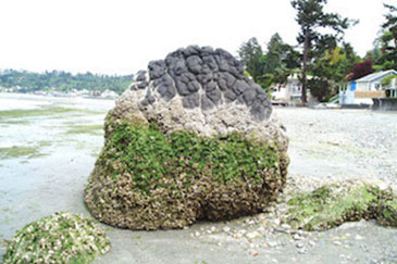
Crying to her mother, “Wait for me,” she sank down, exhausted. There she is to this day in the form of a white rock (now under the east side of the parking lot of Anthony’s Home Port, east of marina Float B.)
Her husband was dressed in a blanket of whistling marmot skins. He was turned into another boulder, down the beach, which looks like a wrinkled blanket. The white people call it Blanket Rock; it now stands on the beach at Redondo.
The parents’ boat and cargo were turned to stone and the poles to trees. Crow, who was the slave of the old people, was carrying water in a basket. This she hid. It turned into a spring on the south slope of Three Tree Point. Hard to find, the spring brings bad luck to those who drink from it.
We call Three Tree Point SqélEb, which means “loading things into a canoe.”
Annie Jack, daughter of Ann Jack, remembered the legend this way:
A young woman from sdagwalul, a village on Quartermaster Harbor (Vashon Island), was married to a man of the tcelpab, living where the town of Morton is now. That man was a hunter and a chief.
The woman was lonesome for her mother and wanted to go home. Not telling her husband, she left when ready. Arriving at the salt water, she followed the beach toward home. She was past Des Moines when “the change” came.
As she was sitting down to rest, she saw her people ready to set out on a camping trip. “Wait,” she shouted.
“Your daughter calls,” the mother said.
“We’ll wait for her,” her father said.
They waited, shoving their boat stern-first toward shore. They had been setting out for the northern end of Vashon Island, the place called taxks, in their raft—two canoes lashed together, carrying a load of luggage.
The raft and its luggage were turned into land. It is the place the white people call Three Tree Point. We call it sx’elab, which means “a load.” Another name is t’aleyAqW, which means “two canoes bound together.”
Crow, the slave of the old people, had a little basket of water near the stern of the raft. All who find that water die. That spring is called kaka’alqo, “Crow’s Water.”
(According to the interpreter, nine people who drank of that water died, including a white child. The interpreter himself once made a search for the spring, intending to plant a flag above it, for a prize of five hundred dollars. This place is also called ka-ka-adi.)
John Xot, a Lower Puyallup Indian born “about 1845,” related this version:
A man of the Tcilpa’bc group, at Big Bottom, married a girl from the salt water. While he was home on a visit, the old people and his young wife, their daughter, broke camp and started for a trip down the Sound.
(“Down the Sound,” for Indians and early settlers alike, meant north, while “up” meant south.)
Their boat was well weighted down, carrying all their luggage. They had gone but a few miles when the girl’s husband returned. Finding the camp deserted, he began to shout and call for his wife.
Hearing the echo, his wife said, “Pull ashore, that is my husband calling.”
No sooner had they turned toward shore than the great change of the world, from the Past to the Present, took place, and the boat and all it contained became the point of land known today as Three Tree Point. The masts of the boat became the trees, the load became boulders and the water they carried became a little spring.
The Indian name for that place means “a load.”
The Man Beheaded While Diving
As told by August James, White River, born about 1885:
A young man had relations with his brother’s wife. The brother made him swim in Bow Lake. The brother’s wife was digging roots on the far shore of the lake, and the young man tried to swim to her. He sank in the middle of the lake and did not come up.
The young man’s parents were digging clams at Three Tree Point. They saw a corpse. It was headless, but there was a tattoo mark on the left shoulder. The mother said, “It looks to me like the body of my son.” (The outlet of Bow Lake is midway between Three Tree Point and Maury Island.)
The parents went up to their son, the husband of the young woman, and said, “What is the matter with your brother?”
“I do not know,” he said.
Afterwards they became angry and killed the young woman.
Nancy Big John, a Duwamish Indian born about 1840, related this version:
Three young men were on a journey from the White River/Duwamish Valley to the bay. One of them, who had stolen a woman, wished to go swimming in a lake. His companions tried to dissuade him, but to no avail.
“I shall go,” he said.
“Do as you like then,” they said.
So he began to swim, farther and farther out until he reached the middle of the lake. Then his two friends saw him whirl around and disappear.
Beyond Three Tree Point at low tide they saw the head of the young man—recognizable because he had had his face painted. They brought the head home to the boy’s parents. The Lake had taken off his head. Now many swim in the lake, but none go out to the center.
Three Tree Point may also have been the site of an Indian burial ground, although it is not certain whether any actual human remains or related artifacts have ever been discovered or unearthed. According to a <em>Highline Times</em> news article, there was a mound on the old Klopfenstein property which may have been the place where an Indian was buried.
Legend had it that an Indian brave wanted to marry the chief’s daughter. When the chief refused, they fought. One died. Local lore also says that an Indian was buried under or near one of the original three trees from which Three Tree Point got its name.
Whether it be through battle, blood or burial, the native peoples of Puget Sound were closely connected to this land, and believed that their spirits would dwell here forever. As Chief Seattle stated in his famous speech in 1854:
“Every part of this soil is sacred to my people. Every hillside, every valley, every plain and grove has been hallowed by some sad or happy event in days long vanished. Even the rocks . . . thrill with memories of stirring events connected with the lives of my people, and the very dust upon which you now stand responds more lovingly to their footsteps than to yours, because it is rich with the blood of our ancestors and our bare feet are conscious of the sympathetic touch.
“Our departed braves, fond mothers, glad, happy-hearted maidens and even the little children who lived here and rejoiced here for a brief season will love these somber solitudes and at eventide they greet shadowy returning spirits.
“And when the last Red Man shall have perished and the memory of my tribe shall become a myth among the White Men, these shores will swarm with the invisible dead of my tribe. And when your children’s children think themselves alone in the field, the store, the shop, upon the highway or in the silence of the pathless woods, they will not be alone.
“In all the earth, there is no place dedicated to solitude. At night when the streets of your cities and villages are silent and you think them deserted, they will throng with the returning hosts that once filled them and still love this beautiful land. The White Man will never be alone.
“Let them be just and deal kindly with my people, for the dead are not powerless. Dead, did I say? There is no death. Only a change of worlds.”
“Discovery”
As Chief Seattle predicted, the White Man’s culture and sheer numbers were destined to overwhelm the Indians of Puget Sound and their age-old way of life. May 1792 seems as good a place as any for when this process began. That was when British naval Captain George Vancouver, on a mission to settle British fur-trading claims against Spain, survey the northwest coast of North America and determine the existence of the fabled “Northwest Passage,” sailed into Puget Sound on his ship Discovery.
The natives, most of whom had never seen white men before, were startled and amazed by the size and speed of Vancouver’s vessel, the booms from his cannon and the many wonders and novelties which some of them witnessed aboard his sleek ship.
Vancouver proceeded to chart the entire area, providing more than 200 geographical names, including Vashon (Island), Mt. Rainier and Puget Sound (named after Lieutenant Peter Puget, the officer in charge of one of the survey boats). Puget and Joseph Whidbey, the expedition’s master sea surveyor, would take a week-long tour of southern Puget Sound, charting its waters and landmarks together in the Discovery’s launch and cutter.
Vancouver followed them in Discovery’s yawl and the cutter of her sister ship, the Chatham. He proceeded south through the Sound’s main channel along the eastern shore of Vashon Island, passing opposite Three Tree Point and Des Moines, where he saw dense clouds of smoke blanketing the thick forests crowding the water’s edge.
(Puget Sound Indians routinely set fire to the woods to make foot travel easier, drive out deer and other game and create open spaces where berries and other sun-loving plants could thrive.)
After Vancouver’s expedition, Puget Sound remained essentially unexplored by Europeans for the next thirty-two years. Then, in 1824, a forty-man expedition led by James McMillan of the Hudson’s Bay Company set out from Astoria to find a passage for small boats (probably Indian canoes, to start with) between the Columbia and Fraser Rivers.
The party reached Eld Inlet at the southern end of Puget Sound on December 4, 1824, spent the night on Vashon Island and continued north to the Fraser River. Returning south through Puget Sound, they were driven ashore by rough weather and spent the evening of December 23 camped at Three Tree Point. They completed the round-trip to Astoria in six weeks.
By 1833 the Hudson’s Bay Company had established posts on the Fraser River and at Fort Nisqually, making Puget Sound an important canoe route between the two. At the time, the Oregon Country was jointly ruled by the U.S. and Great Britain. But the Americans were starting to pay more attention to it.
In 1841 Lieutenant Charles Wilkes was placed in command of U.S. Pacific and Arctic explorations. He proceeded to survey Northwest Coast rivers and harbors, naming many geographical features, including Elliott Bay, Williams Point (in present-day Lincoln Park), Blake Island, Point Roberts (now Alki Point), Maury Island, Quartermaster Harbor and Point Pully, named for Robert Pully, a quartermaster in one of Wilkes’ crews.
(The Washington State Board of Geographic Names changed the name to Three Tree Point in 1975, in deference to the cape’s more popular title.)
Like Vancouver, Wilkes used two boats in charting Puget Sound. Cadwalader Ringgold, one of his lieutenants, set out in the “U.S.S. Porpoise” to survey the eastern shore of Puget Sound from Commencement Bay to Elliott Bay, including the coastline in the vicinity of Three Tree Point.
Like Vancouver, Wilkes was smitten with what he found: “Nothing can exceed the beauty of these waters, and their safety,” he wrote. “There is no country in the world that possesses waters equal to these.”
Beautiful, perhaps, but not always peaceful. In the mid-1850s Indian uprisings prompted local Militia volunteers to build Fort “Lone Tree Point” on the shores of Puget Sound. The fort was probably on or near Three Tree Point, referred to as “Lone Tree Point” on old King County maps.
Not much information survives about the fort, other than that it was a.) built by Captain Chas. W. Riley and sixteen volunteers from Pierce County in early 1856 to protect white settlers, b.) small, housing ten to twenty men, and c.) situated on or near the “available trail leading from the camp of the hostile Indians.” (History of King County Washington, Clarence B. Bagley, 1929.)
The fort’s existence is substantiated by J.A. Eckrom in Remembered Drums: A History of the Puget Sound Indian War. Eckrom writes of a volunteer stationed at the fort, one Lemuel Bills, a “florid-haired Steilacoom eccentric” who, at 54, was the oldest private in the army.
Bills half jokingly advertised in the Steilacoom Courier for a wife—and found an eager taker! Her name was Ellen Brooks, and she referred to Bills in her published letters as “the corndodger of my affections,” encouraging him to enlist and make a name for himself fighting the Indians.
Bills joined the army, marching north with a small company commissioned to garrison the new fort fronting the beach at Three Tree Point.
The fort was intended to block the Indians’ access to the area’s converging trails, segments of which remain in use today as a public footpath. The fort apparently was successful in its mission: no Indian warriors were ever detected slipping down these trails during the War of 1855-’56.
Settlement: 1850-1900
The first non-native settler near Three Tree Point was probably William H. Brown, a thirty-three-year-old pioneer who spotted the homestead site of his dreams while rowing a boat north along the eastern shore of Puget Sound in 1853. Congress had recently passed the Donation Act of 1850, entitling settlers to free land. This evolved into the Homestead Act of 1862, which provided that anyone who was over 21 or head of a family, and was either a U.S. citizen or intended to become one, could obtain 160 acres of public land if he lived on it for five years and made improvements. (A person could make a payment of $1.25 an acre in lieu of the five-year requirement.)
Brown filed his Donation Claim on December 5, 1853 and built a cabin on the Sound near Shoremont. This homesite was likely chosen because it was close to an Indian trail which ran from the Duwamish River to nearby Miller Creek. With no roads in the area at the time, such trails were the only access by land to Seattle and other settlements.
The final deed for Brown’s property—163 acres of cool woods, streams full of fish and a quarter-mile long stretch of clam-laden beach, in what is now Normandy Park—was issued on December 23, 1865. The next homesteader to file a claim in the area was James Howe, for 120 acres on September 20, 1869. This property appears to have included most of the beachfront along the northern shore of Three Tree Point.
The name of Robert Howe (a brother?) is also listed as having filed a claim (exact date not known), for what appears to be about 160 acres of land and waterfront stretching from the tip of Three Tree Point southward to the Normandy Park “Cove.” (According to Homestead Act filing records and King County Archival maps, as reproduced on pages 2-3 of Normandy Park: Wonderful World of Woods and Water, Helen Kludt et al., 1991.)
Meanwhile other homesteaders were moving in from the east. In 1872 young Mike Kelly and his family ventured up the Duwamish River Valley, scaled the forested hill to the west and liked what they saw on the other side. Kelly filed a claim for 160 acres near present-day 146th and 16th South and named the whole area Sunnydale, the approximate borders of which were 110th on the north, the community of Des Moines on the south, Military Road on the east and Puget Sound on the west.
Kelly built a cabin and grew vegetables—including hops—his shed doubling as the community dance hall, meeting place and special events center. His wife taught school in the family’s kitchen. Kelly also built a road connecting his farm with others around the area. The “Kelly Road” ran north to Military Road and extended as far south as present-day 180th, where it turned west and ran all the way to the Brown and Gardner homesteads south of Three Tree Point on Puget Sound.
This road, which was later bricked and survives today as Des Moines Memorial Drive and Normandy Road, encouraged other families to file for homesteads in Sunnydale, and the community grew steadily.
But because most roads were still relatively crude in the 1870s and 1880s, Three Tree Point remained somewhat isolated from other settlements—at least by land. But the Puget Sound “water highway” provided an easy means of getting from place to place around the region for well over fifty years, from the 1850s into the 1900s.
Passengers, freight and mail were transported by canoe, schooner and a fleet of small steamboats (appropriately named the “Mosquito Fleet”) between cities such as Seattle and Tacoma, and flagstops such as Des Moines and Three Tree Point, which were included as ports of call in 1886. In the decade of the 1880s, Seattle’s population grew tenfold—with other Puget Sound cities reaping similar gains—keeping the steamship trade going strong well into the next century.
By the 1890s, with Three Tree Point and Seahurst developing into prime vacation property and a fashionable summer home area, more boat service was needed. Captain Vanderhoef, owner of the steamer “Iola,” upped the number of runs between Tacoma and Seattle to three round-trips per week, including stops at Three Tree Point.
The McDowell Transportation Company, begun in 1898 and using seven boats, enjoyed a thriving business as more and more people flocked to summer resorts on Three Tree Point, Vashon Island and other Puget Sound locales. In its heyday, the Mosquito Fleet made up to eight stops daily at Three Tree Point, between the hours of six a.m. and ten p.m.
As waterfront property grew in demand as a refuge from city life, Seattleites flocked to Three Tree Point on weekend outings, vacation retreats and to look over vacant lots. There was one general store—as allowed by the deed restrictions imposed by the Seacoma Company, original owners of Three Tree Point—as well as a dock, vacation cottages and picnic grounds.
In the Span of a Lifetime: 1900-Present
By the 1900s more and more wealthy people were building summer homes on the beaches north and south of Three Tree Point, and in Seahurst. Yet the only practical way to get to those homes still remained by boat, with foot trails leading up from the dock through the forest.
Residents thus relied on the water for access to the area until about 1918, when better roads and more automobiles finally led to a decline in the passenger boat business and spelled the end of the Mosquito Fleet. The Virginia steamships continued operation between Tacoma and Seattle for many years, but eliminated stops at Three Tree Point.
Meanwhile the 1880s saw more and more settlers arriving in Sunnydale, clearing the land and building log cabins. Wood, ever in abundance, was cut and split for heating and cooking, with any extra being hauled to Seattle and sold for seventy-five cents per cord.
Several small shingle and sawmills sprang up in the area during the 1890s. By 1900 lumber companies were logging around Gregory Heights, cutting the trees and dragging the logs via “skid roads” down the ravines to the present Normandy Park beach, where they were rafted and towed to mills or hauled overland by wagon.
The need for lumber for homes, ship building and military uses greatly increased during World War I. What timber remained in present-day Highline and Gregory Heights was logged off at this time, in response to the increased demand.
About this time (1911) the Highland Park & Lake Burien Railway was organized to improve transportation to and promote development of the area. From 1912 to 1929, a nine-mile stretch of irregular, winding road brought electric railcar service, affectionately known as the “Toonerville Trolley” and “Galloping Goose,” to the area. The railroad went as far as 152nd S.W. and S.W. 21st Ave. in Seahurst.
From there, Three Tree Point residents had to brave the often-muddy roads and trails winding down to the water. An alternate route was opened in 1919 when Sylvester Road was cut through from Five Corners to Three Tree Point.
During Prohibition, Three Tree Point was used as a port of entry for bootleggers operating out of Canada. According to Marguerite Hannan, a resident since 1919, “They used to land on a dock at the Point at night. . . The Sheriff’s cars stood by to make sure they weren’t interfered with. But the feds finally caught up to that.”
The contraband booze was stored in the basement of a local man who was “well-compensated by the bootleggers.” Then, late at night a car would rumble down the dirt road, douse its lights, pick up the cargo and roar up the hill, Hannan remembered.
By 1949 only one of the giant fir trees which gave Three Tree Point its name still stood (in the yard of L.D. Brill). The Miller family, meanwhile, would own and occupy the choice piece of property at the tip of the Point for sixty some years—from 1937 until May 1997. One of the most valuable lots between Seattle and Tacoma, the 1.6 acre parcel includes 600 feet of shoreline and a 300-degree view of Puget Sound, the Olympic Mountains and Mt. Rainier.
Beau and Lonnie Miller, sole owners of Elliott Bay Industries (a Seattle manufacturer of plywood-making equipment), fell behind in their payments to the IRS, which had bought the property from Seafirst Bank. In January 1998 the General Services Administration opened the bidding on the property in a written auction on behalf of the IRS. The winning bid was submitted by Ray and Louise Rice, who moved in shortly thereafter.
Three Tree Point Today and Tomorrow
Maritime activities abound around Three Tree Point. Popular are beach combing, sailing, windsurfing, water- and jet-skiing, kayaking, canoeing, fishing, wildlife observation, scuba diving and just plain enjoying the fresh salt air and spectacular sunsets.
Sailboats are often visible scurrying ’round Three Tree Point. Headquartered in Des Moines, the Three Tree Point Yacht Club was formed in 1969 to organize racing and cruising events, including the Commodore’s Trophy Race for sailing dinghies, and the Duwamish Head Race and Windjammer Series for sailboat racers. The courses for these and other races are frequently laid out using the channel buoy off Three Tree Point
Three Tree Point also attracts scuba divers throughout the year. North of the point, near the site of the old steamship dock, several large artificial reefs can be found at various depths along a steep drop-off which descends 130 feet beneath the surface. This area is rich in sea life, including the rare Puget Sound tortillabranch, lingcod, quillback rockfish, sculpins, sponges and squid.
South of the Point, the underwater landscape, being muddier and flatter, is not as glamorous. But divers continue to explore this site as well, perhaps because of the submerged cars and sailboats reportedly lurking in its murky depths.
Fishing has reportedly made a comeback in recent years at Three Tree Point. In addition to reporting good-sized specimens of the resident blackmouth (chinook) salmon, some anglers are hauling in large kings, silvers and other species of salmon during their respective runs, more so than in years past.
(Charley Ganong is a Burien resident.)